|
|
Post by Alex Liggett on Mar 12, 2015 4:55:18 GMT
Anyone who has created large datasets or those with lots of irregular boundaries in Landonline will be aware that the error messages that crop up are frequently, er, less than self explanatory. I have been meaning for some time to create a thread where we can record some of these, and it just so happens I have been presented with a new one this afternoon. 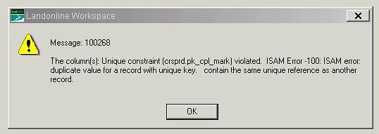 This one was caused by having duplicated an irregular line in an XML being uploaded to Landonline. I suspect a similar one comes up if you forget to make all mark names unique. Remember that you can cut and paste from the Landonline XML Write dialogue box into Excel, where you can easily sort mark names, observations etc to identify duplicates. |
|
|
|
Post by Alex Liggett on Mar 12, 2015 5:07:59 GMT
This humourous little fellow also pops up during XML import: 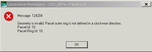 I'm not sure what the actual problem here is, but the normal culprits are parcels consisting of two irregular boundaries and two nodes, such as an island in a river. Fortunately the fix is an easy one. Go to the parcel capture tab in Landonline and unlink the parcel noted in the message (Parcel 10 in the example above). Then go to Capture>Refresh. If there is more than one, Landonline will then bring up the next failure, because it never occured to Landonline's developers that you might want a list of the problems, rather than fixing them one at a time. "For a long time it puzzled me how something so expensive, so leading edge, could be so useless, and then it occurred to me that a computer is a stupid machine with the ability to do incredibly smart things, while computer programmers are smart people with the ability to do incredibly stupid things. They are, in short, a dangerously perfect match." Bill Bryson |
|
|
|
Post by Alex Liggett on Mar 17, 2015 4:15:12 GMT
In fact, this is what you get if you have duplicated mark names: 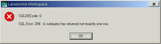 |
|
|
|
Post by Brent George on Apr 15, 2016 5:12:17 GMT
Here's another cryptic LoL error message that is worth noting to help the Help Desk with a solution:
Message 100692 - Unable to delete record because it is reference by other items followed by: Message 29039: An error has occurred when submitting the survey. Contact LINZ etc.
The "error" is often triggered when you are responding to a requisition and you want to resubmit your dataset. It relates to a "behind-the-scenes" adjustment that was run by the plan examiners that is not complete. You have to ask them (via an exception request or 0800 call) to set the adjustment to "complete".
Thence you can happily re-submit your dataset. |
|
|
|
Post by Brent George on Apr 19, 2016 21:43:16 GMT
SURVEY DIAGRAMS NOT DEPICTED CORRECTLY IN PLAN GENERATION:
This issue does not trigger an error message, but it causes you Plan Generation Grief....
It relates to survey diagrams created by polygon, and how they are presented on the survey diagram/plan. The diagram depicted does not match the polygon drawn. In fact, the diagram depicted extends way beyond the area you will have initially selected, and is presented as a rectangle with lines/points/observations crammed along one edge of the rectangle. In other words - a mess.
This is not your draughting problem and if you painstakingly edit the diagram to something you want, there is no guarantee it will stay that way. It relates an adjustment run behind the scenes that LoL does to create the diagram, as it pulls through more information than necessary.
The solution is the 0800 number, to log a request for a LoL expert to fix.... |
|
|
|
Post by Alex Liggett on Apr 20, 2016 20:13:50 GMT
The trick there is that if your data is majorly distorted compared to the existing data in Landonline, it can be worth preemptively getting LINZ to turn off the adjustment of the Plan Gen view (which is what they will do afterward when the poo hits the fan). The good news is that the fix Brent mentions usually pretty much instantly puts your diagrams right again.
|
|
|
|
Post by Alex Liggett on Aug 9, 2016 20:14:53 GMT
A new one today. This message appears in Pre-Validation:  Pre-Validation halts at this point. While we aren't sure what triggers it, going into Capture Dataset, opening the spatial window and selecting Capture > Refresh, then closing and going back to Pre-Validation appears to solve the problem. Let me know if you have the same problem and this doesn't work for you. |
|
|
|
Post by Alex Liggett on Feb 1, 2017 1:27:44 GMT
I just stumbled over this little chap: 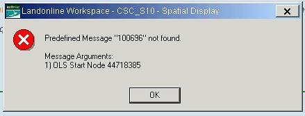 This was on a survey that involved large balance parcels of road. In the intervening time between drawing the plan and lodgement, other surveys intersected on the opposite sides of the balance parcel boundaries ( I should have known, they were my surveys). When I made a minor change, then tried to relink parcels, all of the new intersection nodes came up as mandatory missed marks, and when I tried to accept them with the green tick, the predictably cryptic message above came up. Easily solved by deleting the relevant parcel boundary lines and adopting them anew. |
|
|
|
Post by Brent George on May 25, 2017 1:12:36 GMT
This is not really an 'error message" issue but is certainly an issue that may stump a Lol player....
- Have you been working on a dataset that is presenting with large standard error values and subsequently reporting failures (and high residuals) between new and old non-boundary marks? - Have ben checked, re-checked and triple check your data entry and found no gross errors? - Has the dataset been a stop/start job that you may have created some months ago and have re-started again in order to finalise it? - Have you just spent an inordinate amount of time trying to resolve the problem to no avail?
If your answer is "YES" to most of these, then it may be that this is the issue....
For some reason an old LoL adjustment behind the scenes has 'frozen' a coordinate (or node) and so when the validation runs it reports high residuals.
The work-around (or how I solved my problem) is to note the culprit vectors, and then delete those from the dataset. Then re-enter the vectors to build-up the lines again; re-link parcels; re-generate plans and re pre-validate. The high standard errors and mis-leading failures should have disappeared....
PS: Send LINZ a bill for all the wasted time and effort you will have spent chasing a ghost problem.... 
|
|
|
|
Post by Alex Liggett on Aug 29, 2017 3:31:12 GMT
One of our graduates has just discovered a new error message:  This came up when accepting mandatory missed marks (MMMs) during parcel linking. Two of the MMMs were the only two nodes where an easement parcel that was to be extinguished contacted any of our boundaries. The learning is that every extinguished parcel needs to be connected to the survey network by >1 captured node. |
|
|
|
Post by Brent George on Jul 29, 2019 20:40:19 GMT
Here's another cryptic LoL error message that is worth noting to help the Help Desk with a solution:
Message 100692 - Unable to delete record because it is reference by other items followed by: Message 29039: An error has occurred when submitting the survey. Contact LINZ etc.
The "error" is often triggered when you are responding to a requisition and you want to resubmit your dataset. It relates to a "behind-the-scenes" adjustment that was run by the plan examiners that is not complete. You have to ask them (via an exception request or 0800 call) to set the adjustment to "complete".
Thence you can happily re-submit your dataset. An alternative reason (and fix) for the 100692 error is detailed as follows: If you have this error reported (usually during attempts to submit the dataset); AND your dataset has an instance of a survey mark that is identified as being DISTURBED; AND this disturbed old mark HAS NOT already been captured into Landonline; then you will need to ensure that:
1. You follow the LINZ Knowledgebase guide: LINZ Knowledgebase - Capturing Disturbed Marks - item 1 only. ie: Call the mark NEW and therefore from your plan; select the appropriate Mark Purpose; described it as "IT II SO 12345 disturbed".
2. Ensure that you DO NOT select the radio-button "disturbed" part of the guide (as per items 2 to 6). As there is no mark existing in Landonline, then the link with the old mark is unable to be validated.
|
|
|
|
Post by Alex Liggett on Nov 18, 2020 22:39:45 GMT
Another error message (on XML import) that is a new one for me: 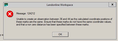 Marks 36 and 44 in my .xml file have inadvertently been linked (in 12d) to the same Landonline node, because they are close together and I have used the Search OID tool in the 12d traverse spreadsheet with a slightly too generous radius. The fix is to OK the message then go through into mark capture and unlink one or both of the highlighted marks. A refresh will then finish the import process. |
|
|
|
Post by Ian Gillespie on Dec 16, 2020 18:57:17 GMT
I also got this error message when I had a strange point id. Probably a typing error gave me a point number of 44.19. One I changed it an integer the dataset uploaded. But boy did it take a long time to find. Anyone who has created large datasets or those with lots of irregular boundaries in Landonline will be aware that the error messages that crop up are frequently, er, less than self explanatory. I have been meaning for some time to create a thread where we can record some of these, and it just so happens I have been presented with a new one this afternoon. This one was caused by having duplicated an irregular line in an XML being uploaded to Landonline. I suspect a similar one comes up if you forget to make all mark names unique. Remember that you can cut and paste from the Landonline XML Write dialogue box into Excel, where you can easily sort mark names, observations etc to identify duplicates. |
|
|
|
Post by Ian Gillespie on Feb 8, 2022 23:44:17 GMT
This message:
C621 - C621 Record of Survey does not include measured vectors to at least 2 other new or old non-boundary marks for every new non-boundary mark that is not disturbed. These vectors must be captured to enable depiction on the survey diagram [CSR 2021 r89(b)]:
May mean that you have a boundary mark (eg an UNMK easement point) incorrectly labelled as a non-boundary mark. - Even though you have a properly closed easement.
|
|
|
|
Post by Alex Liggett on Feb 28, 2022 20:51:39 GMT
That's great intel, thanks Ian. We seem to be getting that error a lot.
|
|


